Severe winter weather is returning; what’s going on with La Niña?
On Thursday, the Midwest and Northeast will experience an Arctic cold front, leading to additional lake-effect snow around the Great Lakes.
A high-pressure system will push cold air across the Upper Midwest on Thursday, with temperatures dropping 15 to 25 degrees below normal in parts of the northern Plains and upper Mississippi Valley. These conditions will also result in dangerously low wind chills, prompting cold weather advisories in parts of North Dakota, Minnesota, and Wisconsin, according to the National Weather Service.
“The extremely low wind chills, potentially as low as -35°F, can lead to frostbite on exposed skin in as little as 10 minutes,” cautioned the Duluth, Minnesota weather office.
AccuWeather meteorologist Alex Sosnowski stated, “The severity of the cold air will diminish slightly as it moves across the bare ground of the Midwest and the warmer waters of the Great Lakes. However, it will still be felt as far south as the Ohio and Tennessee valleys, and east to the Appalachians and Atlantic coast from Thursday to Friday.”
Regionally, in the West, the harsh Santa Ana winds are expected to decrease in Southern California, aiding efforts against the Franklin Fire in Malibu.
Lake-effect snow impacting the Great Lakes
Heavy lake-effect snow is occurring downwind from the Great Lakes this Thursday, as reported by the weather service.
Areas expecting snow accumulation between 12 and 24 inches include parts of northern Michigan, southwestern Ontario, northeastern Ohio, and northwestern Pennsylvania, according to AccuWeather. However, some regions in western and northern New York could receive between 24 and 36 inches of snow.
A state of emergency is now in force for at least twelve counties in western New York, where snowfall is anticipated to reach up to three feet by Friday. State officials have also implemented several road restrictions due to the hazardous conditions.
As Thursday night turns into Friday, snowfall is expected to decrease in intensity across most regions, but moderate to heavy lake-effect snow could pick up again downwind from Lake Ontario on Friday, according to the weather service.
Santa Ana winds calming down
The strong Santa Ana winds that have been affecting Southern California this week, contributing to the Franklin Fire in Malibu, are predicted to lessen on Thursday. Humidity is also expected to rise in Southern California, aiding in fire containment efforts.
Rain and snowfall at higher elevations will move into Central California on Thursday, bringing light snow to the Sierra Nevada over the next few days, according to the weather service.
La Niña is not here yet; what does this mean for winter weather?
On Thursday morning, federal forecasters announced that the anticipated La Niña weather pattern is not yet officially present, and the reason remains unclear.
“It appears that our models have recently predicted temperatures to be too low,” stated Michelle L’Heureux from the Climate Prediction Center during an interview. “While the sea-surface temperatures in the tropical Pacific have been cooler than usual, they have not yet met our thresholds for La Niña.”
She acknowledged that “the window for La Niña to develop this winter is becoming narrower.”
Nonetheless, forecasters project a 59% likelihood of La Niña conditions forming by January 2025, with about a 61% chance transitioning to “ENSO-neutral” conditions between March and May 2025.
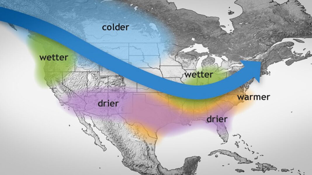
La Niña is characterized by notably cooler ocean temperatures in the Equatorial Pacific and can result in varied weather patterns, leading to floods and droughts globally.
If it does materialize, “this event is expected to be weak,” said Johnna Infanti from the Climate Prediction Center. “Even weak events tend to favor typical La Niña outcomes, yet the impacts are less predictable,” she added.
In terms of winter weather across the U.S., typical effects of La Niña include wetter than average conditions in the Pacific Northwest and Ohio Valley, while the southern states often experience drier conditions, as noted by Weather.com. For temperatures, “the north-central U.S. typically sees colder than average conditions during La Niña winters, while the South can have warmer than average temperatures although there may still be colder periods,” Weather.com explained in an online report.

