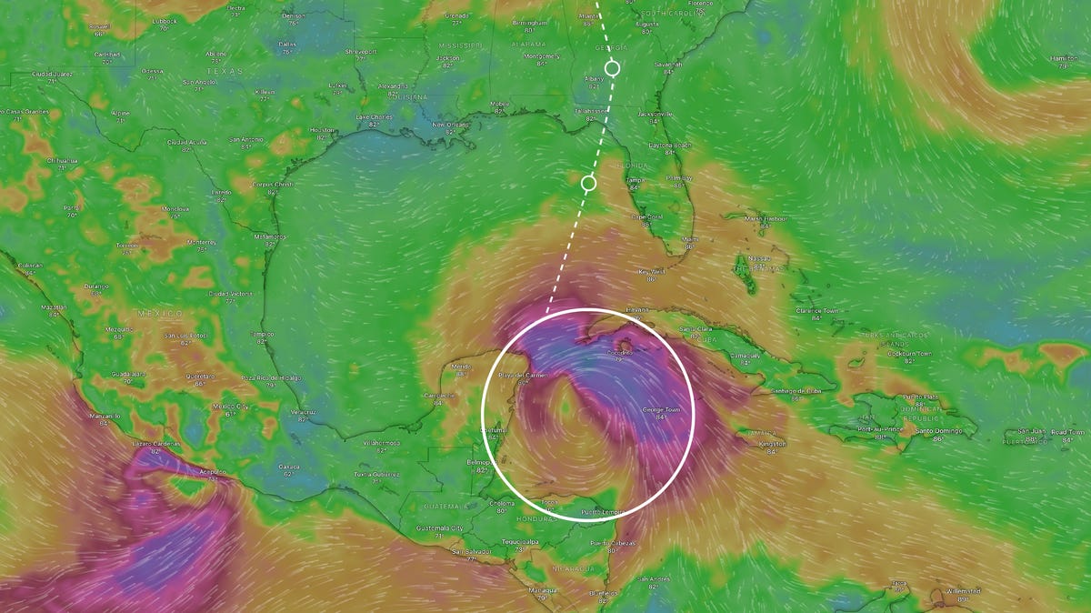
Potential of Gulf Coast Storm Becoming Category 3 Hurricane Helene – A Major Threat to Florida
A powerful storm currently in the Caribbean is anticipated to become a significant Category 3 hurricane by Wednesday, named Helene, and it might strike Florida’s Gulf Coast with winds reaching 115 mph by Thursday.
The National Hurricane Center has warned that the storm, now identified as Tropical Storm Helene, poses threats of dangerous storm surges, strong winds, and heavy rainfall.
Forecasters, including AccuWeather’s lead hurricane expert Alex DaSilva, emphasized that the Florida Panhandle and Big Bend area from Tallahassee to Gainesville should brace for potential hurricane effects.
AccuWeather Chief Meteorologist Jon Porter remarked, “This could be the defining storm of the 2024 hurricane season.”
On Monday afternoon, Governor Ron DeSantis declared a state of emergency for 41 out of Florida’s 67 counties that are along or close to the Gulf Coast, which includes the entire Panhandle.
As reported in the 8 a.m. ET advisory from the hurricane center, the storm was located roughly 150 miles west of Grand Cayman and had maximum sustained winds of 35 mph.
The system was tracking northwest at around 9 mph but is expected to accelerate and shift to a north-northeast direction by Wednesday and Thursday, according to the hurricane center.
According to its current trajectory, Helene is anticipated to cause severe weather across Florida and the Gulf Coast, bringing heavy rains as far north as Georgia and the southern Appalachians, as reported by YSL News.
Helene Could Be the Fourth Hurricane This Year to Impact the US
If the storm makes landfall as a hurricane, it would be the fourth to affect the U.S. mainland this year:
- Beryl: Category 1, Matagorda, Texas, July 8
- Debby: Category 1, Big Bend region of Florida, Aug. 5
- Francine: Category 2, Morgan City, Louisiana, Sept. 11
Current Advisories Being Issued
- Storm Surge Watch: From Indian Pass south to Bonita Beach, including Tampa Bay and Charlotte Harbor.
A Storm Surge Watch indicates that there is a risk of life-threatening flooding from water rising from the coast to inland areas over the next 48 hours.
- Hurricane Watch: For the Gulf Coast of Florida from Englewood northward and westward to Indian Pass, including Tampa Bay.
A Hurricane Watch means that hurricane conditions could occur within the monitored region. Such watches are generally issued 48 hours prior to the expected onset of tropical-storm-force winds.
- Tropical Storm Watch: For the Gulf Coast of Florida from Indian Pass to the Walton/Bay County line and from north of Bonita Beach to south of Englewood.
A Tropical Storm Watch indicates that sustained winds between 39 to 73 mph may occur within 48 hours due to a tropical, subtropical, or post-tropical cyclone.
Contributing: Dinah Voyles Pulver, Minnah Arshad, Christopher Cann, Gabe Hauri, and Doyle Rice from YSL News; Cheryl McCloud from Tallahassee Democrat
Source: Reporting and research from YSL News Network; National Hurricane Center; National Oceanic and Atmospheric Administration; Reuters

