Storm Update: National Hurricane Center Monitoring Tropical Depression Joyce and Four Other Weather Systems
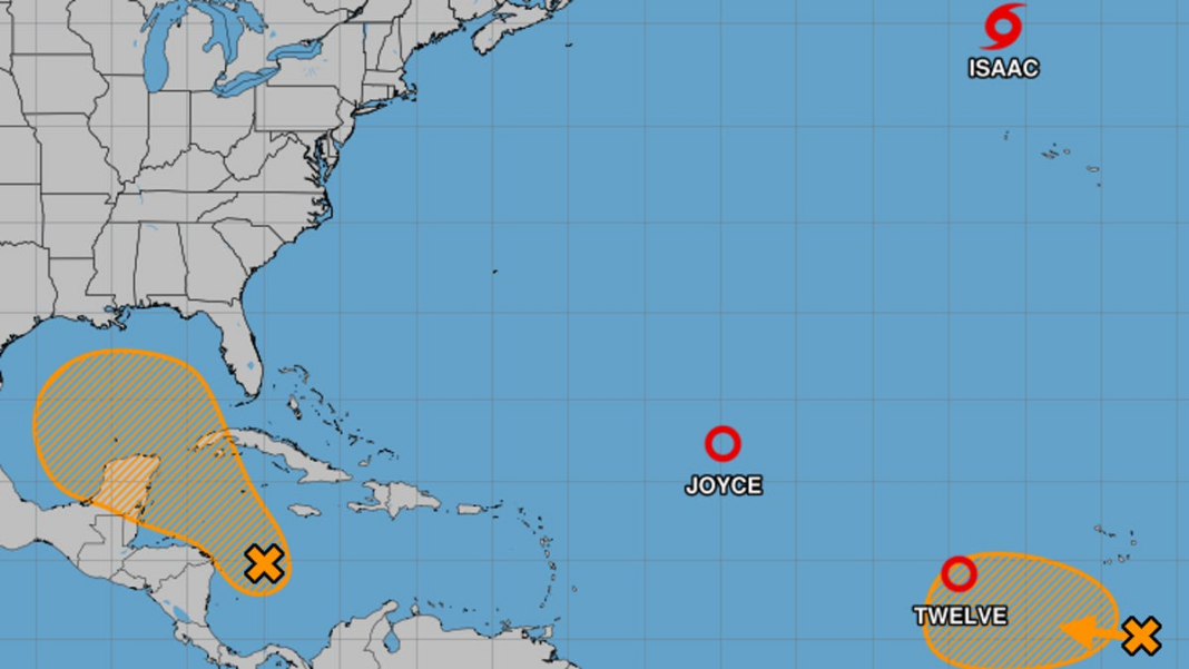
Weather experts at the National Hurricane Center are keeping an eye on five weather systems in the Atlantic, which include one tropical storm and two tropical depressions.
The system that poses the most significant threat to the United States is currently in the Western Caribbean Sea and the Gulf of Mexico. The NHC reported on Monday that a “broad area of low pressure” in this region is generating scattered showers and thunderstorms. The conditions are favorable for slow development.
It is anticipated that a tropical depression may emerge around the middle of this week as the system drifts slowly west-northwest, and it is expected to enter the Gulf of Mexico later this week.
The NHC advised that “people in the northwestern Caribbean Sea and along the U.S. Gulf Coast should keep an eye on this system.” The chance of development is currently estimated at 40% over the next seven days.
Additionally, the NHC noted that a tropical wave located a few hundred miles south-southeast of the Cabo Verde Islands is showing “limited shower and thunderstorm activity,” with an 80% chance of developing into a tropical depression later this week.
Tracking Atlantic Storms
Tropical Depression Joyce and Tropical Storm Isaac Show Signs of Weakening
The NHC predicted that Tropical Depression Joyce would continue its weakening trend over the next 48 hours. It is likely to downgrade to a post-tropical remnant low by Monday evening and may completely dissipate by Wednesday.
Tropical Storm Isaac was located approximately 515 miles north-northwest of the Azores on Monday morning and is expected to shift northwestward at a consistent speed on Tuesday, according to the NHC.
“Gradual weakening is forecasted for the next several days,” the NHC stated Monday morning, predicting that Isaac will also turn into a post-tropical cyclone later on Monday.
Tropical Depression Twelve to Strengthen into a Large Hurricane This Week
The last system under scrutiny by the hurricane center, known as Tropical Depression Twelve, is situated around 690 miles west of the Cabo Verde Islands.
As of Monday morning, the NHC expects a “general westward to west-northwestward motion” to persist through Tuesday, followed by a gradual shift to the northwest predicted for Wednesday.
This system currently has maximum sustained winds of approximately 35 mph, with stronger gusts reported. The NHC anticipates “steady strengthening,” and it is likely that this depression will evolve into a hurricane by Tuesday night or Wednesday.
Forecast models suggest that this system will curve northward into the central Atlantic, well clear of the U.S. mainland.

