Hurricane Center Monitoring Three Disturbances in the Atlantic: Is There a Threat to the U.S.?
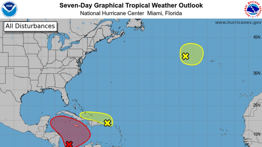
The National Hurricane Center announced on Friday that it is observing three weather systems in the Atlantic, including one that is expectedto evolve into a tropical depression in the near future.
The National Hurricane Center (NHC) indicated that a “wide area of low pressure” is expected to form over the southwestern Caribbean Sea within the next day or so, with “slow development” possible afterward.
On a positive note for those monitoring from the U.S., meteorologists report that it is unlikely for the storm to move too far north due to “unfavorable” winds.
The hurricane center has assessed a 70 percent likelihood of formation for this system over the upcoming week. The next named storms of the
The upcoming 2024 Atlantic hurricane season will see hurricanes named Patty and Rafael.
According to forecasters at the hurricane center, a tropical depression is expected to develop either late this weekend or early next week as it moves through the Caribbean Sea.
“Despite ongoing development, there may be significant rainfall in some areas of the western Caribbean,” according to the National Hurricane Center (NHC).
Will the upcoming storm impact the United States?
Experts predict that most long-term forecasts indicate that this system is unlikely to reach the U.S., thanks to strong winds in the Gulf of Mexico. “The unfavorable wind shear typical for this time of year in early November suggests it won’t make it,” they added.
As meteorologist Michael Lowry from WPLG-TV pointed out in his recent blog, the situation is developing.
AccuWeather reports that a high-pressure system forming over the East Coast of the United States next week may be powerful enough to drive weather patterns towards Central America or Mexico.
The National Hurricane Center announced on Friday that it is monitoring three weather disturbances in the Atlantic. One of these could potentially develop into a tropical depression as early as this weekend or by early next week.
impacts to parts of Mexico and Central America in the coming week. However, according to Lowry, it is improbable that the U.S. will experience any notable effects due to unfavorable winds expected in early November. He mentioned that even if the system shifts north toward the central or northern Gulf next week, it would likely be rapidly weakened by strong wind shear affecting much of the northern and central Gulf of Mexico.
The hurricane center is also monitoring two additional systems in the Atlantic, although both are currently deemed unlikely to develop significantly.The initial system, identified by the National Hurricane Center (NHC), is referred to as a “trough of low pressure” situated close to Puerto Rico. This system is generating extensive showers and thunderstorms across parts of the Greater Antilles, as well as in the surrounding Atlantic waters and the northeastern Caribbean.
There is a possibility for this system to gradually develop over the upcoming days while it progresses west-northwestward near the…
The National Hurricane Center (NHC) indicated on Friday morning that a weather system is currently over the Greater Antilles. However, it is anticipated that this system will merge into a low-pressure area in the Caribbean shortly thereafter.
Despite the uncertain development of this system, significant rainfall is likely in the upcoming days across regions from the northern Leeward Islands to Puerto Rico and Hispaniola, extending to eastern Cuba and southeastern Bahamas, according to NHC forecasts.
In addition, there is another weather phenomenon identified as a “storm-force non-tropical low pressure area,” positioned approximately 400 miles west of the Azores. This particular system is generating some limited shower activity along with potential for slight subtropical development.
It is anticipated that the system will continue to move eastward over the next few days, as per the National Hurricane Center (NHC).

