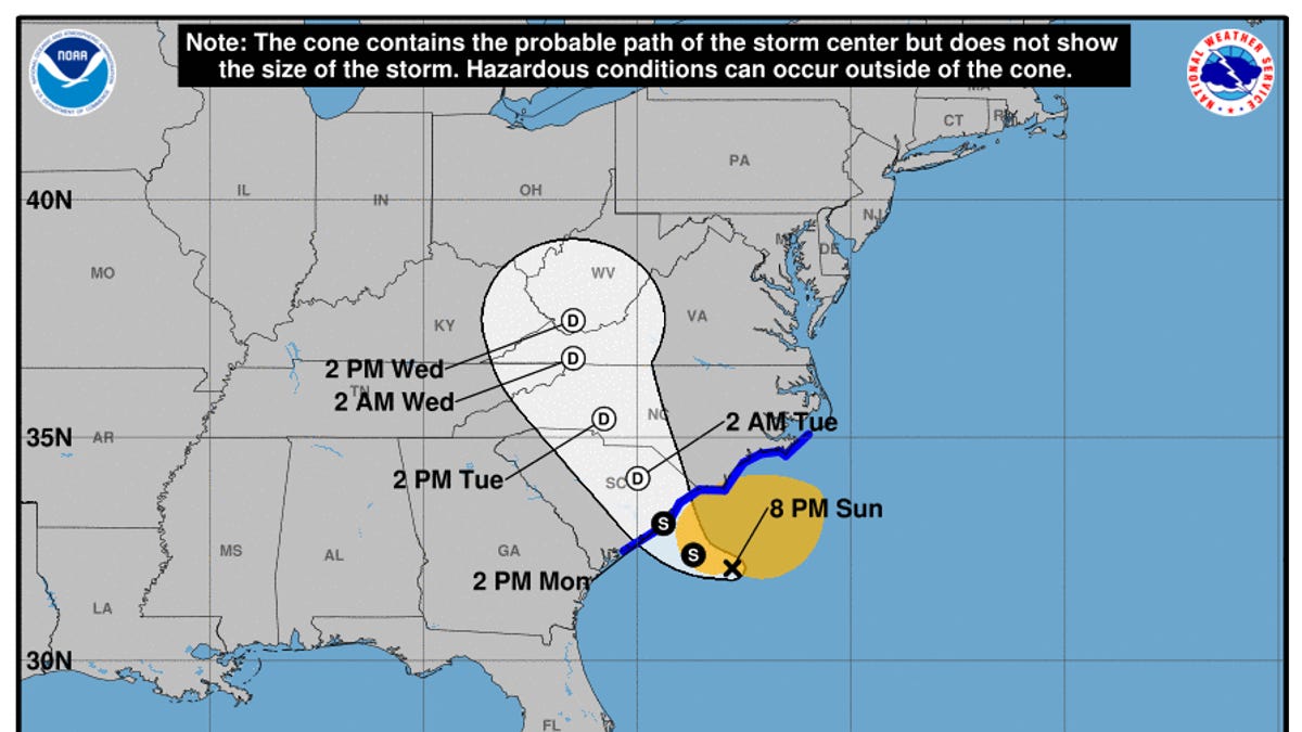
Storm approaching Carolinas potentially brings 10 inches of rain and flooding risks
North and South Carolina are preparing for strong winds, heavy rains, and possible floods and tornadoes as a Potential Tropical Storm Eight is set to hit on Monday.
As of Monday morning, the “low-pressure system” had not yet graduated to a tropical storm according to the National Hurricane Center, but it was strengthening slowly while moving northwest at 3 mph towards South Carolina’s coast, located about 100 miles east of Charleston, with maximum sustained winds of 50 mph.
The storm is predicted to reach South Carolina shores on Monday afternoon and will traverse both Carolinas throughout the night into Wednesday, as noted by the hurricane center in a morning briefing.
If this storm is classified as a tropical storm, it will be named Helene, following the naming convention. However, the likelihood of this occurring has diminished as the storm has shown a less organized structure and forecasters expect its wind speeds to decline as it nears land.
A tropical storm warning was issued for extensive areas in both states on Monday morning, with forecasts indicating possible “gusty winds, significant rain, and coastal flooding,” according to the National Hurricane Center. Even if it doesn’t reach tropical storm status, the region could still experience strong winds.
The storm could inundate the hardest-hit regions with up to 8 inches of rain, with isolated areas possibly receiving up to 10 inches, as per the advisory. The hurricane center also cautioned that “a few” tornadoes could develop in the eastern regions of both Carolinas through Monday night.
This rainfall might lead to “locally significant flash and urban flooding” across the Carolinas and raise the risk of isolated flooding across the entire Mid-Atlantic region, according to the advisory. Minor flooding is also expected along rivers in southeastern North Carolina and northeastern South Carolina through Monday night.
Recent updates:
∎ The National Hurricane Center indicated that the storm is anticipated to gain minimal strength prior to landfall. Once inland, it is expected to weaken until it dissipates on Wednesday, according to forecasters.
∎ The combination of elevated tides from the full moon, large waves, and strong northeast winds are likely to lead to high tides along the coast, resulting in minor to moderate coastal flooding early in the week, as per the weather service’s prediction. Additional storm development could also heighten the chances of more severe coastal flooding.
∎ A storm named Gordon has diminished its intensity in the Atlantic and was downgraded to a tropical depression by 5 p.m., according to the National Hurricane Center, which stated it posed no risk to land.
Some schools in North Carolina cancel classes due to weather
Due to the potential for tropical storm conditions on Monday, several schools in North Carolina will be closed.
Brunswick County Schools announced on Facebook that students should remain home while teachers will have an optional workday.
Additionally, Brunswick Community College will close on Monday due to the severe weather, with remote classes occurring where feasible.
Schools in New Hanover and Pender counties will continue with their normal schedules.
— Sherry Jones, Wilmington StarNews
Swimmer safety risks in Outer Banks of North Carolina
The Outer Banks of North Carolina are notorious for dangerous currents, and the new weather system has raised these risks, according to a Sunday update from the weather service.
Fortunately, the highest likelihood for powerful rip currents to occur was projected to be a few hours before and after low tide, which was expected before noon on Sunday. However, the risk remains, and the update advised inexperienced swimmers to avoid entering the water.
“Rip currents can pull even the strongest swimmers far from the shore into deeper waters,” the alert warned. “Hazardous shore break can throw a swimmer or surfer headfirst into the ocean floor, leading to neck and back injuries.”
Contributing: John Bacon and Thao Nguyen, YSL News

