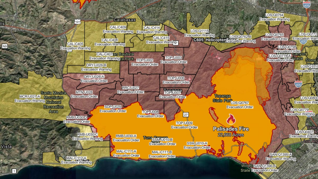
Current Mandatory Evacuation Zones Due to California Wildfires: Check LA Maps.
A severe series of wildfires in the Los Angeles area has resulted in evacuation orders affecting more than 153,000 individuals as of Saturday, announced Los Angeles County Sheriff Robert Luna at a press briefing.
Additionally, evacuation alerts have been issued for another 166,000 residents who should remain ready to leave. Over 57,000 buildings are currently at risk, and approximately 38,000 acres have burned due to the fires, notably the Palisades Fire, which is the most devastating in the history of Los Angeles.
Weather experts have cautioned that strong winds could exacerbate the situation leading into the upcoming week.
Alana Alejo, a Target security guard who has been in LA since 2007, evacuated her residence in the Encino area on Friday. She mentioned that she chose to leave ahead of any evacuation order after noticing ashes in the air. She took valuable items, her agitated pet hamster, and an emergency food stash she had assembled for such emergencies.
“I was panicking while trying to keep calm,” Alejo expressed to YSL News Friday evening outside the Lanark Recreation Center, designated as an evacuation site. “It’s incredibly distressing to witness this. Many of my friends have lost everything, their homes reduced to rubble. This situation is very serious.”
Here’s the latest on where evacuation orders are in effect across California as of Saturday afternoon, along with how to stay informed on updates.
Evacuation Orders for the Palisades Fire
Evacuation orders are currently enforced in Los Angeles County, specifically south of the Pacific Coast Highway, north of the Encino Reservoir, east of the 405 Freeway, and west of Mandeville Canyon.
According to the Los Angeles County Sheriff’s Department, all evacuation mandates and warning regions due to the fire are subject to a curfew from 6 p.m. Friday until 6 a.m. Saturday, as reported by Cal Fire.
Residents can find a complete list of evacuation zones and check their status using the Cal Fire website. An interactive map outlining the evacuation orders and alerts for the Palisades Fire is also accessible.
Evacuation Orders for the Eaton Fire
As of Saturday afternoon, evacuation orders are in effect for regions surrounding Altadena and Pasadena, as noted by Cal Fire.
Residents can view a complete list of evacuation zones and determine which one they are in by visiting the Cal Fire website. An interactive map displaying the evacuation orders and alerts for the Eaton Fire is also available.
Evacuation Status for the Hurst Fire
As of Friday afternoon, all evacuation orders and warnings for the Hurst Fire were lifted, according to Cal Fire.
For an interactive map of Hurst Fire evacuation orders and warnings, visit the Cal Fire website.
Evacuation Status for the Kenneth Fire
Evacuation orders and warnings for the Kenneth Fire were also lifted on Friday afternoon, affecting areas in both Los Angeles and Ventura counties.
Check the Cal Fire website for an interactive map of Kenneth Fire evacuation orders and warnings.
This story has been updated to reflect new information.

