Hurricane Rafael tracker: Storm expected to land in western Cuba on Wednesday
Hurricane Rafael is gaining strength and is projected to reach significant hurricane intensity when it hits western Cuba on Wednesday, as reported by the National Hurricane Center.
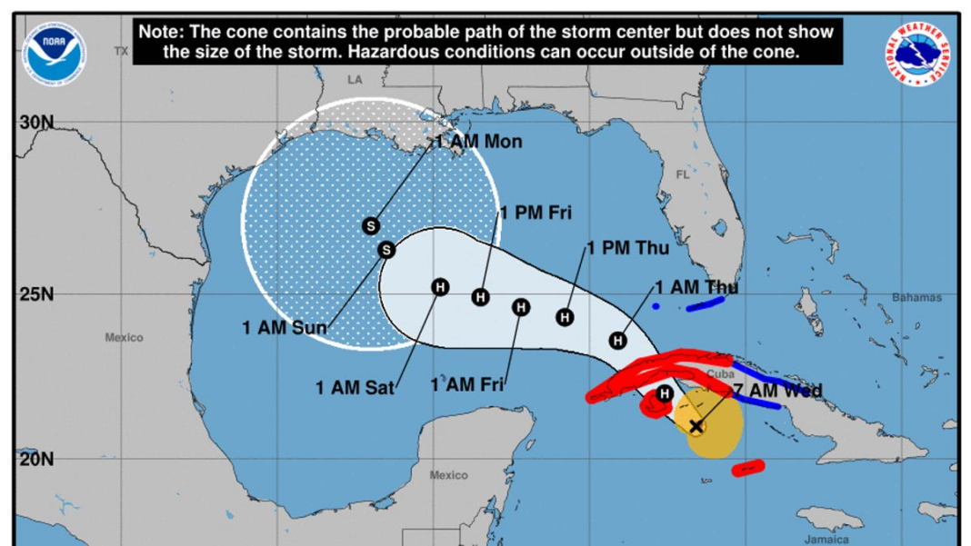
As of Wednesday morning, Rafael was situated approximately 160 miles south-southeast of Havana, Cuba. The storm is heading northwest, and this general motion is expected to continue for the next day or so, with a subsequent shift to a west-northwest direction in the Gulf of Mexico.
According to the NHC’s advisory on Wednesday morning, “On the forecast track, Rafael is expected to approach or pass near the Isle of Youth later this morning or early this afternoon, making landfall in western Cuba later today.” The storm is also expected to enter the southeastern Gulf of Mexico tonight.
Currently, Rafael boasts maximum sustained winds around 100 mph, with even stronger gusts anticipated. Rapid strengthening is on the horizon, and the hurricane center suggests it could be “near major hurricane intensity” right before landfall. While some weakening is expected as it crosses Cuba, Rafael should re-enter the Gulf of Mexico as a hurricane.
On Tuesday afternoon, Rafael brushed past the west coast of Jamaica, prompting the opening of four emergency shelters; fortunately, officials reported no fatalities or injuries from the heavy rainfall.
Heavy rain is predicted to affect parts of the Western Caribbean through early Thursday, particularly affecting Jamaica, the Cayman Islands, and western Cuba, according to the NHC. Rainfall is estimated between 4 to 7 inches for the Cayman Islands and western Cuba, with localized amounts potentially reaching up to 10 inches in elevated areas.
Florida Keys could be affected starting Wednesday
The hurricane center forecasts tropical storm conditions for parts of west-central Cuba as well as the lower and middle Florida Keys on Wednesday afternoon and evening.
Expected rainfall in the lower and middle Florida Keys ranges from 1 to 3 inches, and the region may also experience a few tornadoes, particularly in the far southwestern area of Florida.
What about the Gulf Coast?
There is still some uncertainty in the long-term forecast, making it too early to predict any potential impacts from Rafael on sections of the northern Gulf Coast. By the end of the week, swells are expected to extend across much of the Gulf.
Forecasts suggest the storm may reach land anywhere from the Texas coastline to the Florida Panhandle during the weekend, as reported by AccuWeather, which indicates that the central Louisiana coast has the highest likelihood of experiencing landfall as a tropical storm. Other scenarios include the storm veering westward to approach the western coast of Mexico.
The positive aspect is that drier air and stronger vertical wind shear in the Gulf should diminish the hurricane’s strength by the time it nears the U.S. mainland. AccuWeather’s forecast indicates, “This is not expected to be a scenario involving a strengthening major hurricane making landfall in the U.S., but rather something of lesser intensity in terms of wind strength.”
Hurricane Rafael path tracker
This forecast track shows the most likely route of the storm’s center, but it does not represent the full breadth of the storm or all its impacts. The center may deviate outside the cone as much as 33% of the time.

