Could Sara Turn into a Hurricane Impacting Florida? Some Projections Indicate So
A new storm might reach Florida next week as a Category 3 hurricane, adding to an already severe Atlantic hurricane season that has resulted in over 326 fatalities and around $120 billion in damages.
Forecast models suggest the storm, which will be named Sara, could achieve winds exceeding 111 mph and trigger intense flooding and storm alerts in Central America by this weekend. The Gulf Coast has already experienced five hurricane landfalls this season.
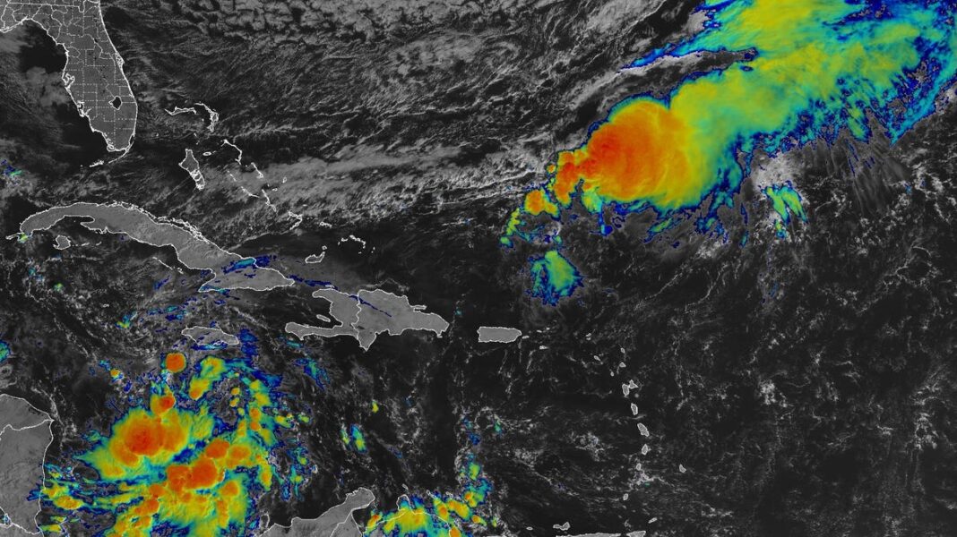
Forecasters from the National Hurricane Center describe the storm as “Potential Tropical Cyclone 18,” which is currently a tropical wave advancing westward through the Caribbean. It is predicted to become Tropical Storm Sara by Thursday.
As of 4 p.m. Wednesday, the storm was approximately 460 miles east of Isla Guanaja, Honduras. Honduras has enacted a hurricane watch, while Nicaragua has initiated a tropical storm watch.
The hurricane center projects the storm could bring up to 30 inches of rainfall to northern Honduras.
Some computer models predict that Sara could evolve into a significant hurricane that poses a threat to Florida’s shores, but forecasters caution that it’s still “too soon to assess the potential impacts” on the Gulf of Mexico, Florida, and Cuba, as stated in the latest update at 4 p.m.
The center’s preliminary forecast suggests a tropical storm may approach the coast of Honduras on Friday, where it may linger for a few days as a tropical storm before potentially making landfall in Belize by Monday. Heavy rain is expected in Jamaica over the next day or two, and in Central America through early next week.
AccuWeather reported in a forecast on Wednesday afternoon that it expects the storm to strengthen into a Category 3 hurricane over the weekend.
Chief Meteorologist Jon Porter from AccuWeather expressed increased concern about the risk of life-threatening flooding in Central America, especially in hilly regions of Honduras and Nicaragua, which have previously experienced severe flooding disasters. He mentioned past tragedies, such as Hurricane Mitch in 1998 that resulted in over 11,000 deaths and significant flooding from Hurricanes Eta and Iota in 2020.
The storm’s interaction with Central America and surrounding weather systems will be critical in determining its strength and path. Since the storm is still developing and lacks a well-defined center, the forecast track is characterized by unusually high uncertainty, as noted by the hurricane center.
The storm may take advantage of “some unusually favorable late-season conditions” to intensify early next week, according to Michael Lowry, a hurricane specialist at WPLG-TV in South Florida.
Warmer water temperatures in the Caribbean and record-high temperatures in the Gulf of Mexico have been observed this week, which are instrumental in hurricane development, as explained by Brian McNoldy, a senior research scientist at the University of Miami’s Rosenstiel School.
Lowry and other meteorologists point out that two main factors will influence whether the disturbance could potentially threaten the U.S. By early next week, the system is expected to start moving slowly northwest, but the timing of this turn could significantly affect its strength and location.
“Should a tropical storm or hurricane emerge in the western Caribbean, its trajectory will likely be strongly influenced by the positioning of a high-pressure dome along the southern Atlantic coast of the U.S.,” according to AccuWeather’s recent assessment.
Currently, the unpredictable nature of the model tracks suggests “high uncertainty” in the forecasts, Lowry mentioned. If the storm passes over Central America or the Yucatan Peninsula in Mexico, it may weaken. Conversely, if it remains offshore in the Caribbean, it may intensify and potentially head towards the Gulf of Mexico by mid-next week.
Given the current environmental conditions, several forecasting models indicate that a potential hurricane could attain Category 3 levels, featuring winds over 111 mph, with one model even predicting the possibility of it reaching Category 4 status, as outlined by meteorologist Levi Cowan on his Tropical Tidbits website.
If this sixth hurricane were to make landfall along the Gulf Coast, it would tie the historical record from 1886 for the most landfalls in a season. Currently, with five landfalls, 2024 aligns with 2005 and 2020 for the second-highest number of Gulf hurricane landfalls in a single season.
Hurricanes in November are uncommon. Records from NOAA indicate only three hurricanes have previously impacted the U.S. or made landfall in November, occurring in 1861, 1935, and Hurricane Kate in 1985.
Active Hurricane Season of 2024
As of now, the 2024 hurricane season ranks as the 11th most active since satellite observations began in 1966, according to Phil Klotzbach, a senior research scientist at Colorado State University. The cyclone energy index determines a season’s overall energy using both storm frequency and the highest wind speeds of hurricanes throughout their durations.
Notable active years include 2005 and 2020, where the hurricane center ran out of initial names and utilized a backup list, Klotzbach noted. Out of the seven most active hurricane seasons recorded, all but two occurred in this century.
The current 2024 season has largely aligned with the preseason forecasts made by NOAA and Colorado State University regarding the number of hurricanes and major hurricanes. The only area lagging behind the predictions is the count of named storms. Although the season started out with high activity, including an unprecedented storm named Beryl, a downturn in activity was observed in August, but since early September, 12 named storms have been recorded.
| Seasonal Outlook issued May 2024 | NOAA | Colorado State | Current Season |
| Named storms | 17 – 25 | 23 | 17 |
| Hurricanes | 8 – 13 | 11 | 11 |
| Major hurricanes | 4 – 7 | 5 | 5 |
Hurricanes Making Landfall in 2024
Beryl – struck Matagorda County, Texas
Debby – affected Taylor County, Florida, and South Carolina
Francine – hit Terrebonne Parish, Louisiana
Helene – impacted Taylor County, Florida
Milton – made landfall in Sarasota County, Florida

