Current Mandatory Evacuation Orders for California Wildfires: Explore the Maps
A “Particularly Dangerous Situation (PDS) Red Flag Warning” will take effect in Southwest California on Tuesday morning.
Ventura County has declared evacuation orders due to the ongoing wildfire crisis in California. This region joins other parts of the Los Angeles area that are also facing evacuation due to life-threatening wildfire conditions, as much of Southwest California is categorized as having an extreme “fire danger,” according to officials.
As reported by the Los Angeles medical examiner’s office, at least 24 fatalities have occurred, and over 12,300 structures have been lost to the wildfires in Los Angeles County, as stated by Cal Fire. Evacuation orders remain in effect in several zones, particularly due to the immediate threats posed by fires such as the Palisades Fire.
A large portion of Southwest California is under Red Flag Warnings, which indicates a “high risk for rapid fire growth if a fire starts,” according to the National Weather Service (NWS).
Currently, there are four active fires in Los Angeles and Ventura Counties: Palisades Fire, Eaton Fire, Hurst Fire, and Auto Fire, according to Cal Fire. It is worth noting that the Hurst Fire is 97% contained and does not have any evacuation orders active at the moment.
Regarding the Palisades Fire, Eaton Fire, and Auto Fire, the following areas are under mandatory evacuation orders.
‘Particularly Dangerous Situation’
Starting Tuesday morning, a “Particularly Dangerous Situation (PDS) Red Flag Warning” will commence, indicating a high potential for the following risks, as conveyed by NWS Los Angeles:
- Severe fire behavior
- Quick fire escalation
- Power failures
- Public Safety Power Shutoff (PSPS)
- Numerous fallen trees
According to the NWS, extreme fire weather along with strong winds is creating conditions that could lead to fires starting and spreading throughout Southern California. Gusty winds are projected to persist through Wednesday in both Los Angeles County and Ventura County.
Wildfire Locations and Evacuation Zones Map for Los Angeles Area
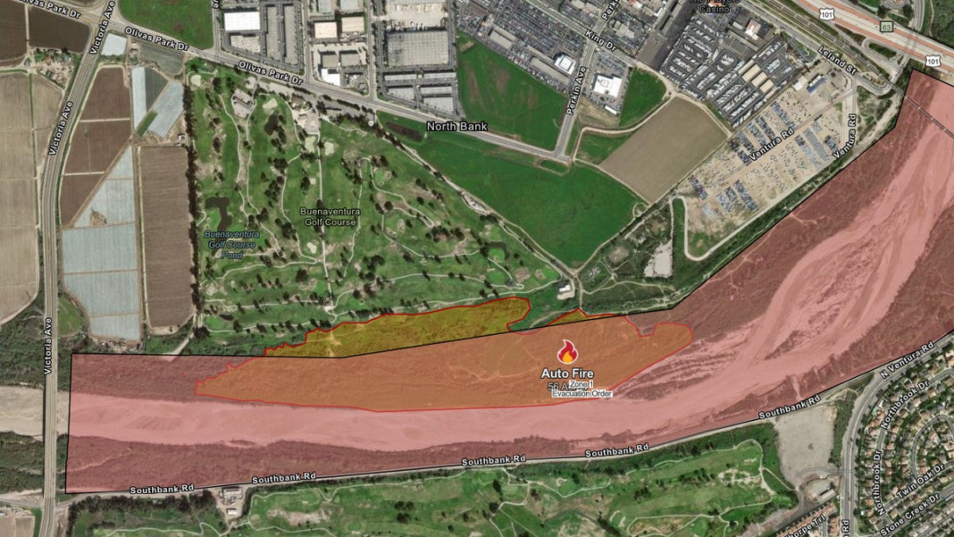
Auto Fire
Size: 56 AcresContainment: 0%County: Ventura
The Auto Fire is situated near Auto Center Drive in Ventura, California, as noted by Cal Fire. This fire was reported on Monday at 9:25 p.m. local time.
There is currently no curfew issued by Cal Fire for individuals impacted by the Auto Fire.
As of Tuesday at 8 a.m. ET, only one area remains under evacuation, per Cal Fire:
- Auto Fire Zone 1 – This area includes the Santa Clara River near Ventura Road and Auto Center Drive.
The roads of North and South Victoria Avenue close to the fire are restricted from Olivas Park Drive to West Gonzales Road, as indicated by Google Maps.
“The fire has been contained to the river bottom, and no structures are currently in danger,” stated the Ventura County Fire Department in a post on X.
Palisades Fire
Size: 23,713 AcresContainment: 14%County: Los Angeles
All regions with evacuation orders and warnings have a curfew from 6 p.m. to 6 a.m., as per Cal Fire.
The following zones are under mandatory evacuation:
- DRY-U026-A
- LOS-Q0406-A
- LOS-Q0407
- LOS-Q0751
- LOS-Q0762
- LOS-Q0762-A
- LOS-Q0765
- LOS-Q0767
- LOS-Q0778-A
- LOS-Q0780
- LOS-Q0781-A
- LOS-Q0782-A
- LOS-Q0782-B
- LOS-Q0798
- LOS-0798-B
- LOS-Q1115
- LOS-Q1118
- MAL-C111-A
- MAL-C111-B
- MAL-C112-B
- MTN-U028
- RMB-U030-B
- RMB-U030-D
- RMB-U030-E
- RRC-U027
- SAN-Q1395-B
- SAN-Q1396-B
- SDP-U029
- SSM-U010-A
- SSM-U010-B
- TOP-U001
- TOP-U002
- TOP-U003
- TOP-U004
- TOP-U005
- TOP-U006
- TOP-U007
- TOP-U008
- TOP-U009
For the latest list of evacuation orders, please check Cal Fire’s website.
Palisades Fire Evacuation Orders and Warnings Map
A list of shelters for those evacuating due to the Palisades Fire is available on Cal Fire’s website.
As of Monday morning, students at the University of California, Los Angeles, are not under any evacuation order, according to the university’s update on X, formerly known as Twitter.
“I recognize that these times are tough, filled with anxiety and uncertainty,” said UCLA Chancellor Julio Frenk. “However, the solidarity and generosity throughout our Bruin community is truly encouraging.”
Eaton Fire
Size: 14,117 AcresContainment: 33%County: Los Angeles
While zones impacted by the Palisades Fire have curfews, Cal Fire has not indicated any curfew for the areas affected by the Eaton Fire.
The areas under mandatory evacuation are as follows:
- ALD-ARROYOSECO
- ALD-CALAVERAS
- ALD-CANON
- ALD-CASITAS
- ALD-CHANEY
- ALD-EASTLOMA
- ALD-EATONCANYON
- ALD-FARNSWORTH
- ALD-GARDEN
- ALD-LAUREL
- ALD-MEADOWS
- ALD-MENDOCINO
- ALD-MIDLOTHIAN
- ALD-MILLARD
- ALD-MOUNTLOWE
- ALD-PALM
- ALD-RUBIO
- ALD-WAPELLO
- ALD-WHITEPARK
- KIN-KINNELOA-A
- LAC-E165-B
- LAC-E167
- LAC-E168-A
- LAC-E183
For updates regarding evacuation orders, check Cal Fire’s website.
Eaton Fire Evacuation Orders and Warnings Map
A current list of shelters for those evacuated due to the Eaton Fire is available on Cal Fire’s website.
Julia is a trending reporter for YSL News. Connect with her on LinkedIn, follow her on X, formerly known as Twitter, Instagram and TikTok: @juliamariegz.

