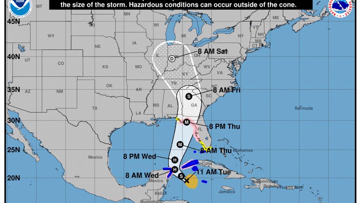
Tropical Storm Helene has formed, forecasted to hit land as a hurricane on Thursday
Parts of the Florida Gulf Coast are under hurricane and storm surge watches as Potential Tropical Cyclone Nine has intensified into Tropical Storm Helene, according to the National Hurricane Center.
As per the latest advisory at 11 a.m. ET from the hurricane center, the storm is positioned approximately 180 miles east-southeast of Cozumel, Mexico, with maximum sustained winds reaching 45 mph. The system is currently moving northwest at 12 mph, a trajectory that is expected to persist into early Wednesday, followed by a faster movement to the north-northeast on Wednesday and Thursday.
“Helene’s center is set to traverse the far northwestern Caribbean Sea tonight before crossing the eastern Gulf of Mexico on Wednesday and Thursday, likely hitting the Gulf Coast of Florida late Thursday,” stated the NHC in its latest briefing.
The hurricane center also indicated that further strengthening is anticipated, with Helene expected to evolve into a hurricane by Wednesday. Following that, the storm may continue to grow stronger, potentially transforming into a major hurricane by Thursday.
Current Watches and Warnings for Florida
According to the National Hurricane Center, a Storm Surge Watch is in effect from Indian Pass to Bonita Beach in Florida, covering Tampa Bay and Charlotte Harbor.
A Hurricane Watch has also been issued for the Florida Gulf Coast from Englewood to Indian Pass, including Tampa Bay.
A Tropical Storm Watch is in place for the Gulf Coast of Florida from Indian Pass to the Walton/Bay County Line and from just north of Bonita Beach to just south of Englewood, along with the Middle Florida Keys, stretching from Seven Mile Bridge to Channel 5 Bridge, according to the NHC.
A Tropical Storm Warning has been issued for the Lower Florida Keys west of the Seven Mile Bridge and the Dry Tortugas.
NHC Monitoring Another System in the Atlantic
On Tuesday, the hurricane center reported that it is also monitoring another tropical wave near the Cabo Verde Islands.
The NHC noted that shower and thunderstorm activity with this system has intensified since yesterday, and conditions seem favorable for gradual development.
There is a “likely” chance of formation into a tropical depression within a few days, as the system moves westward across the eastern and central tropical Atlantic, with an 80 percent chance of development in the upcoming week.
This article has been updated with new information.
Gabe Hauari is a national trending news reporter at YSL News. Follow him on X @GabeHauari

