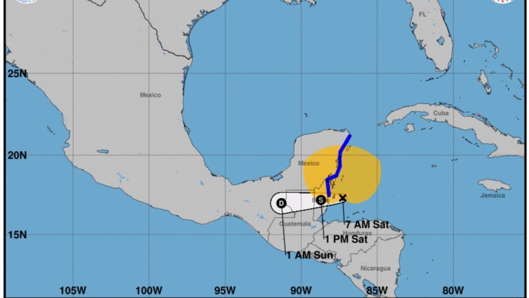
Tropical Storm Nadine brings rainfall; another system may form into Oscar
The National Hurricane Center is closely monitoring Tropical Storm Nadine, which developed early Saturday morning. Additionally, they are observing another system in the Caribbean that has the potential to become a tropical depression or storm.
As of 8 a.m. ET on Saturday, Tropical Storm Nadine was situated approximately 60 miles east of Belize City and 105 miles southeast of Chetumal, Mexico, according to the hurricane center. The storm is packing maximum sustained winds of 45 mph and is moving westward at a speed of 9 mph.
Tropical Storm Warnings are in effect for Belize City and areas ranging from Belize to Cancun, Mexico, including Cozumel. The storm is expected to bring widespread rainfall of 4-8 inches, leading to localized flash flooding in southern Mexico, northern Guatemala, and northern Belize.
Conditions associated with the tropical storm are anticipated along certain coasts of Belize and Mexico’s Yucatan Peninsula through Saturday afternoon, with isolated areas potentially receiving over 12 inches of rain by late Tuesday.
Fortunately, Nadine does not pose a risk to the United States. As the storm progresses inland, it is likely to weaken and could dissipate over southeastern Mexico by early Sunday, according to the officials.
Monitoring system 94L in the Caribbean
The National Hurricane Center is also focused on another system in the Atlantic, referred to as AL 94 or Invest 94L. This system is generating showers and thunderstorms less than 100 miles to the east of the Turks and Caicos Islands. Moving westward at 10 to 15 mph, the system is expected to pass north of Hispaniola today and approach the Turks and Caicos, southeastern Bahamas, and extreme eastern Cuba on Sunday.
Forecasters indicate that this system is “becoming better organized” and is anticipated to evolve into a tropical depression or storm on Saturday, with warnings potentially for those islands, as well as for southeastern Bahamas and eastern Cuba. The likelihood of its formation in the next week is projected at 90%, according to the center.
This system is predicted to intensify until it passes Hispaniola and Cuba later this weekend, likely either dissipating or continuing as a disorganized tropical rainstorm in the western Caribbean, as per a forecast by AccuWeather’s senior meteorologist Alex Sosnowski on Saturday.
When does the 2024 hurricane season conclude?
There are roughly six weeks left in the 2024 Atlantic hurricane season, which generally spans from June 1 to November 30. So far, the season has seen 14 named storms. The next storm to arise will be given the name Oscar.
After a relatively calm five weeks, the 2024 hurricane season, particularly with the emergence of Helene and Milton, has evolved into an above-average season, noted meteorologist Phil Klotzbach from Colorado State University. He mentioned that typically, the 14th storm in the Atlantic forms around November 19, as stated in a post on X, the platform once known as Twitter.
Through October 28, meteorologists from Colorado State University predict a 50% chance of tropical development. “There are indications of potential additional development in the western Caribbean as the forecast period progresses, although these signs are relatively weak,” added CSU forecasters.

