Storm Tracker: North Carolina Hit by Heavy Rain, Gordon Could Strengthen into a Tropical Storm
A developing tropical system unleashed unprecedented rain in parts of southeastern North Carolina on Monday, leading to warnings of “life-threatening flash flooding,” as reported by weather officials.
Areas including Carolina Beach, Boiling Springs Lakes, and Southport saw more than a foot of rainfall within the first 12 hours, which typically is an event that occurs only once every 200 years, according to the National Weather Service in Wilmington, North Carolina.
In Carolina Beach, over 18 inches fell in just half a day, an occurrence the agency flagged as happening “once every 1000 years!”
To ensure safety, the North Carolina Department of Transportation urged residents in impacted areas to refrain from driving if possible, sharing an image of a collapsed and largely submerged road in Southport as the storm inundated dozens of routes.
This weather system, labeled Potential Tropical Cyclone Eight, is expected to move northward across the Carolinas towards the Mid-Atlantic in the coming days based on forecasts from the NWS. More rain and thunderstorms are anticipated in parts of North Carolina and southern Mid-Atlantic regions on Tuesday, prompting the risk of both “isolated and scattered flash flooding.”
As of Tuesday, flood watches remain in effect for certain areas of southeastern Virginia and North Carolina, with a forecast indicating a decline in rainfall on Wednesday.
“By Thursday, the system is set to drift offshore into the Atlantic, with high pressure beginning to form behind it,” the NWS stated on Tuesday morning.
National Hurricane Center Monitoring Tropical Depression Gordon, Along with Three Other Tropical Waves
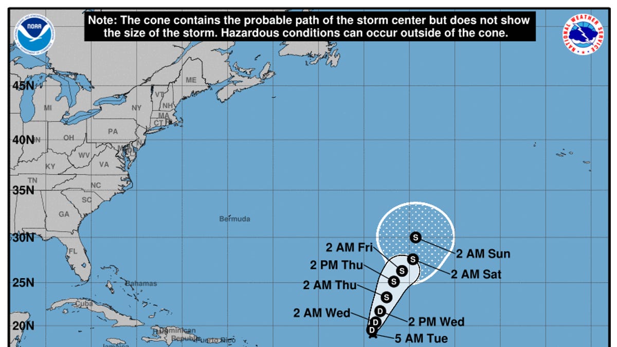
This morning, the National Hurricane Center announced it is monitoring Tropical Depression Gordon, situated about 925 miles east of the northern Leeward Islands.
The NHC noted that while the depression is currently moving west, a shift to the north is anticipated on Tuesday, which will be followed by a turn toward the north-northeast on Wednesday.
With sustained winds near 35 mph and stronger gusts, Gordon could gradually regain strength and become a tropical storm later this week, according to forecasts from the NHC.
Additionally, the hurricane center is observing three tropical waves in the Atlantic, according to updates shared Tuesday morning.
One tropical wave in the eastern Atlantic is currently located along 27W, south of 20N, and is moving westward at a speed of 5-10 knots. Meanwhile, another tropical wave in the central Caribbean Sea is contributing to increased showers and thunderstorms in northern Colombia and the south-central Caribbean region, as noted by the NHC.
Lastly, a tropical wave extending from southern Yucatan to Guatemala and into the Eastern Pacific has also been identified, with the NHC reporting a few showers occurring near this system.
Tracking Tropical Depression Gordon
Tropical Depression Gordon Forecast Models
Spaghetti model illustrations represent a range of forecasting tools and models, which have varying levels of reliability. The Hurricane Center typically relies on the top four or five most accurate models for its predictions.
Gabe Hauari is a national trending news reporter at YSL News. Follow him on X @GabeHauari

